opens in new tab or window
Skip to main content
Menu
Search
Home
Explore
Events Calendar
Things to Do!
Activities
Wandering Trails
Galleries, Museums & Collections
History & Heritage
Uralla Shire Villages
Parks and Town Pool
Boutique & Specialty Shops
Clubs and Societies
Wooldridge Fossicking Area
Tourist Drives
Tourist Drive 17 - The Best of New England High Country
Tourist Drive 21 - Eucalyptus, Sculptures & Fine Wool
Tourist Drive - Aniwan Dreaming
Stories of Uralla
There's Something About Uralla
History and Heritage
See Uralla
Getting to Uralla
Wine & Dine
Local Beer & Distilled Spirits
Dobson's Distillery
Dining in the Uralla Shire
Michael's Cafe & Catering
Caffe Gusto
The Top Pub
The Bolt Inn (The Bottom Pub)
53 On Bridge
Restaurant Pinot
The Pie Mechanic
The Alternate Root
Invergowrie Store
Bundarra - Longevity Country Kitchen
Stay
Aurelia's Farm
Bushranger Motor Inn
Altona Motel
Country Road Caravan Park
Dingle B&B&B
Elmswood AirBNB
Grace Cottages
The Bolt Inn
The Top Pub
Queen Street Uralla Caravan Park
Bundarra Caravan Park
Commercial Hotel, Bundarra
Woodhaven Cottage, Kentucky
Camelia Cottage, Kentucky
Lochiel Cottage, Kingstown
Retreat Shearers' Quarters
Salisbury Street Townhouse
Unique solar passive design, near Armidale or UNE
King's Cottage & The Bower @ Kings Cottage
Morning View Studio
Eve Flower Shop Residence
Uralla Showground Camping
Abbondanza Accommodation
The Huts at Taylors Run
Uralla Shire Council
Home
/
Explore
/
Things to Do!
/
Wandering Trails
/
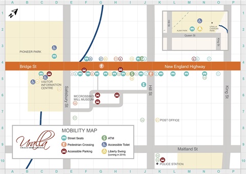
Uralla Mobility Map
In This Section
Events Calendar
Things to Do!
Activities
Wandering Trails
Bulagaranda (Mount Yarrowyck) Aboriginal Area
Dangar's Lagoon & Racecourse Lagoon
Mount Mutton Walking Trail
Uralla Creek Walk Sanctuary
Fairy Map & Story
Uralla Soundtrail
Uralla Mobility Map
Galleries, Museums & Collections
History & Heritage
Uralla Shire Villages
Parks and Town Pool
Boutique & Specialty Shops
Clubs and Societies
Wooldridge Fossicking Area
Tourist Drives
Stories of Uralla
Getting to Uralla
Uralla Mobility Map
Pick up a copy of the map from the Visitor Information Centre!
Back to top